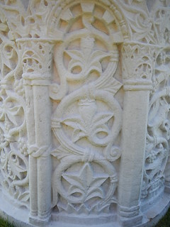
General notes on Image 11
- This is the image for August and the immigration reference is to Italy.
- This image is thought to be linked to Verse 3 and the location is thought to be Boston, Massachusetts.
- The proposed solution for this casque is given on the Image 11 Verse 3 Solution page.
- There was a claim in October of 2019 that the Boston casque had been found. We have a page on the wiki where contributors are welcome to discuss the claim and share and evidence that leads them to believe it or doubt it.
- Please note: Many of the clues on this page point to the Back Bay Fens in Boston. The guidelines for The Secret specifically ruled out any possibility that a casque could be buried in "any public or private flower bed." That would rule out all of the Kelleher Rose Garden, so please do not do any digging there. We don't want to create problems for the gardeners who maintain that beautiful space.

Specific Observations
Please record your notes about this image in the list below. Use the letter/number grid to identify the point on the image that you're describing. To keep things organized, 1) please start each observation with a letter/number combo (in bold), and 2) add new observations in the right place on the list to keep everything alphabetized.
- C4 & K9 - These perfectly round, small craters in the stone seem significant. There's another one in Image 8.
- E2, C3, C7, & E9 - The lines in the top of the arch were long thought to show a set of numbers (possibly because of the similarity to numerals around a clock face). The more likely interpretation is that they correspond to cuts in the pavement on a sidewalk (see image matches below).
- E6 - The single star (or planet) is similar to the star in Image 8. The star could represent a streetlight at the "4-shaped" lines on the sidewalk.
- H1 - There are letters faintly written along the edge of the circle.
- J3 & K8 - The area where her hair fans out looks similar to a sky-line, or perhaps piers extending into a river.
- J7, K7, & L7 - The wavy blue lines on the woman's sleeve are clearly meant to tell us something. If they are letters, they may spell out "BOS" in a possible reference to Boston. If they are numbers, the might be showing "1105."
- J7, K7, & L7 -The wavy blue lines on the upper, left arm could also be a reference to the Muddy River flowing through the arm-shaped Back Bay Fens (as in this map). The Back Bay Fens form the shape of a left arm, running from a shoulder at the Boylston Street Bridge, to an elbow at the Gardner Museum, to a wrist at Brookline Avenue.
- J8 - The jewel is a peridot, the birth stone for August.
- J8 - The fairy holding the jewel may be modeled on a figure in a painting called The Red Cross Knight, illustrating a scene from The Faerie Queen (see below).
- J9 - The cracks in the wall could be a map of streets or paths.
- K3 - There is clearly something written on the woman's right elbow. It could be the number 70 backwards, or it could be something else.
- K5 - There are several places that have been identified as possible matches for the castle shown on the jewel box (see below).
- K6 - The number "42" is on the bracelet, possibly as a latitude hint (see below).
- K9 - The number "112" is written on the wall, with a "2" below. It's possible that the "112" is the middle part of a reversed Boston zip code, 02115, which would include parts of the Back Bay Fens and the Emerald Necklace, but not Mother's Rest or the Victory Gardens.
- L4 - The uppermost symbol on the woman's stole is hidden in the shadows, but it appears to be the numeral "2" turned sideways in a box. That might represent Massachusetts Route 2, which passes through Beacon Street and Kenmore Square and has the symbol of a plain "2" in a box (see below).
- L8 - The flower is a gladiolus, the birth flower for August.
- M1 - Some faint dark lettering above the "railing" but below the bubble appears to spell out "XXII." There may also be an "L" to the right of the bird.
- M2 & M4 - The two floating bubbles are very similar to the floating bubbles of Image 3.
- M2 - The bird could be a peregrine falcon or a gyrfalcon. It could also be a representation of Horus. There is a stone sculpture of Horus in the courtyard of the Isabella Stewart Gardner museum, which borders the Back Bay Fens on the south side (across Fenway).
- M4 & M7 - Some of the shapes on the stole hanging from the woman's garments could be maritime signal flags.
- N1 - Between the horizontal lines on the wall there appears to be some faint blue numbers that may be 74.902.
- N2 - The lifted leg of the falcon creates a mysterious silhouette of a pig's head. It could be a reference to the Porcellian Club at Harvard, but few other clues point in that direction. There are (at least) two restaurants in central Boston with "pig" in their names, but web searches seem to indicate that The Squealing Pig opened in 1998, and The Salty Pig opened in 2011. The strongest interpretation is that the pig is actually a reference to bacon and is meant as a playful reference to Beacon Street (see below).
- N2 - The bird is standing on a T-shaped perch. This could be a reference to the Boston-area public transportation system (the MBTA), which is often called "the T" because its logo shows a capital T in a circle. There is a Kenmore MBTA station at Kenmore Square and it is marked on maps and on the street with the "T" logo. The Kenmore station is five stops (steps?) from the Park Street hub and it is the closest stop to Fenway Park.
- N7 - The triangle inside the square may be a reference to the iconic Citgo sign in Boston's Kenmore Square. The square is at the intersection of Beacon Street and Commonwealth Avenue, which ties in with several other clues. If the broad line behind the pig represents Beacon Street (Bacon Street), it makes sense that the line would cross both the T-shaped perch and the triangle design.
- O2 - There appears to be a face and possibly something else in the faded design on the wall.
- O3 - The initials of the artist are written below the tail of the bird: JJP.
- O8 - The arch with the squares at the bottom of the picture is sometimes thought to represent the Hatch Memorial Shell on the Charles River Esplanade. Alternatively, it could be a match for the Boylston Street Bridge or one of the other arched stone bridges in the Back Bay Fens.
- P1 & P2 - The tabletop in the lower left corner is an odd addition that doesn't appear to serve any purpose. It may represent a utility box near the 2C site (see image matches below).
- P7 - The floating sheet at the bottom middle of the image doesn't serve any obvious purpose, but it must be there for a reason. It's too reflective to be paper, but it's thin and slightly flexed, as if to rule out a mirror.
Other Notes:
- The facial features of the woman match up well with the statue of Christopher Columbus in Christopher Columbus Waterfront Park. But several parts of the image match up well with features found in or near Boston's Back Bay Fens. The hints in Verse 3 also seem to point to both of those two places. It's possible that searchers are meant to start at the statue and then progress to the Fens. The "five steps" in the verse might be metaphorical references to city blocks, subway stops, freeway exits, or something similar.
- The two definitive sources for information on the public parks in this area are the Back Bay Fens Preservation Master Plan, which was written in 1977, and the Emerald Necklace Parks Master Plan, which was written in 1989 and updated (with annotations) in 2001.
- This image seems to be paired in some way with Image 1. Both images feature prominent, solitary women looking directly at the reader. Both have symbols made of squares and triangles, and both feature winding designs that resemble vines. There is one moon in Image 11 and there are eleven moons in Image 1. Perhaps most significantly, both images appear to have a connection to a place named "Strawberry Hill."
- This image also seems to be paired in some way with Image 3. Both images show central figures in front of arched, stone windows at nighttime. Both also feature floating bubbles.
- This image may also be connected in some way to the drawing that appears on the title page of The Secret.
Image Matches
|
A credible case could be made that the various objects in the lower half of the painting spell out the letters of BOSTON. The circles could just be circles, of course, but the T, N, and S seem very clear and deliberate. The B is only slightly more subtle.
The nice thing about this interpretation is that the T in "BOSTON" would therefore represent "the T" in Boston, which no doubt would have amused Byron Preiss. |
 |
|||||||||
|
The woman has a strong facial resemblance to the Christopher Columbus Statue located in Christopher Columbus Waterfront Park in Boston's North End. This would make sense with both the connection to Italy and the presence of the globes in the painting.
According to the inscription on the pedestal, the statue was dedicated in October of 1979, which would have made it still a new and notable feature when Preiss visited in 1982.
|
 |
 |
||||||||
|
The woman's hands are positioned similarly to those on the Columbus statue in Columbus, Ohio. The match is very similar in both size and position (though the right is obviously rotated).
Also, note that both Columbus statues feature the "orb stool" seen in the very bottom right of Image 11. |
 |
  |
||||||||
|
The strange shape formed by the woman's hair just above the gladiolus could represent the piers that extend into Boston Harbor. The North End is Boston's Little Italy, and the piers in this area curve out like in her hair.
Note that, in the satellite image at far right, Christopher Columbus Waterfront Park is the green space on the north side of the New England Aquarium. The wharf in that area extends out at an angle and then bends halfway through. The bend and the projections are very similar to the shape formed by the woman's hair. |
 |
|
||||||||
|
The box in the woman's left hand is the central focal point of the entire painting. It features a castle with these distinctive features:
The final feature may be the most important one. There are many structures in Boston that are built in a Romanesque Revival style featuring cylindrical towers capped with conical roofs. (One notable example is the fire station at the corner of Boylston St. and Hereford St.) Some of these structures also have battlements and pitched roofs, but - with one known exception - the conical roofs on the towers always form straight lines to the tip.
|
 |
|||||||||
|
One potential match that has been found for the castle on the box is Boston's Armory of the First Corps of Cadets, located at the intersection of Arlington Stree and Columbus Avenue. It has battlements, a pitched roof, narrow windows arranged on a diagonal, and two towers, one wide and one narrow. The tower heights are reversed in the painting and the narrow, offset windows are moved from the skinny tower to the wide tower, but - most distinctively - the wide tower still has the distinctive acuminate or tapering tip.
The armory was built in the 1890's and over the years it has been used for many purposes, including a library and a Smith and Wollensky steak house. It is currently being used as an event space called Castle at Park Plaza. |
 |
 |
||||||||
|
Another possible match for the castle is the Boston University Castle. It has battlements with the same number of openings as the battlement on the box. It also has a pitched roof at the same perspective as the image.
The tower on the Image 11 box looks very similar to several towers that Palencar inserted into Image 5.
The photo on the right features two interpretations of how the Boston University Castle may be featured in Image 11. Also, notice the towers from Image 5 (Chicago) added as a reference. The Image 5 towers contain many of the same features (offset windows, etc.) as the tower in Image 11. These towers in Image 5 were of no importance to guiding the hunter to the Chicago Cask, they were used to obscure the real clue which is the Chicago Water Tower. Palencar may have been using the same technique in Image 11.
Notably, the entrance to the Boston University Castle is flanked by two gateposts topped with spheres, as shown in the photo.
The Boston University Castle is located on Bay State Rd. across Storrow drive from the Charles River Esplanade, at the end of Back St. where it curves and becomes Granby.
|
 |
 |
||||||||
|
The fairy holding the jewel may be modeled on the character of "Faith" in a painting called The Red Cross Knight, which was painted by Boston artist J.S. Copley. The painting illustrates a scene from The Faerie Queene by Sir Edmund Spenser. Copley Square in Boston is located a few blocks north of Columbus Avenue between Clarendon and Dartmouth Streets.
Note that there appears to be a four-leaf clover in the fairy's wing.
The fairy may also be connected in some way to the statue on the fountain at Statler Park, which is holding a bowl in both hands and balancing on an orb. Statler Park is on the opposite corner of Columbus Ave. from the Castle at Park Plaza. |
 |
 |
||||||||
|
The wall to the right of the jewel has a pattern of cracks that resembles a map. It's possible that the pattern represents an intersection of roads at the mouth of the Back Bay Fens, where the Muddy River meets the Charles.
The lower right corner of the pattern forms a quarter note (also called a crotchet). If the other lines represent a map, the musical note might represent either the Boston Conservatory or the Berklee College of Music, both of which are located beside the Back Bay Fens where Boylston Street meets Fenway.
Alternatively, the green and orange lines could both be Boylston Street, and the blue line would be Fenway.
Either way, the map would lead us to an area of the Back Bay Fens near a playground called Mothers Rest. |
|
|
||||||||
|
The jewel held by the fairy is a peridot, the birthstone for August, but the cut of this one makes it resemble an emerald. The shape and angle of the jewel, as it is held here by the fairy, matches the rectangles in the neckline of the woman's dress. It's possible that this is meant as a reference to the Emerald Necklace, a string of public parks in the Boston area.
The necklace could also be a match for the belt buckle on one of the figures in the John Boyle O'Reilly memorial located beside Mothers Rest in the Back Bay Fens. |
 |
 |
||||||||
|
The outline of the bird, the perch, and the lifted talon forms the shape of a pig's head in profile. The head appears to grow out of horizontal lines running across the wall.
It is possible that the pig is a reference to bacon and the lines are meant to be a street, and the combination of the two ("bacon" + "street") forms a rebus for "Beacon Street" (one of the major streets in Boston).
If you want to get really silly, you can add in the beak of the bird to make a rebus of "beak + bacon + street = Beacon Street." That would explain the need for the bird in the picture.
|
 |
|||||||||
|
The bird's perch forms a thick, sans-serif, capital "T" and it is shaded to appear mostly black. In Boston, a symbol like this on maps or street corners indicates a stop for the public transportation system (known locally as "the T").
The Kenmore T Station is beside Beacon Street where it reaches Kenmore Square. The Kenmore T Station is the closest subway stop to Fenway Park and its fabled "Green Monster."
|
 |
Licensed under Public Domain via Commons. |
||||||||
|
The woman in the figure appears to be a priestess of some kind and she is wearing a stole that hangs down from her vestments behind each of her arms. The stole is decorated with various symbols, each contained inside a rectangle.
Directly across from the "bacon" + "street" rebus for Beacon street (and within the lines that would define the street) there is a triangle symbol on the stole. One of the iconic symbols of Boston is the enormous Citgo sign located on Beacon Street at Kenmore Square.
|
 |
|
||||||||
|
The "double A" symbol near the top of the stole on the left might be a reference to street grids. If so, it could be a reference to Beacon Street, where it intersects Bay State Road and Commonwealth Avenue just north of the Kenmore T station and just northeast of Kenmore Square. |
|
|
||||||||
|
Directly above the double-A symbol on the stole, there is a "2" inside a square and turned sideways. (The image at near right shows the symbol as it is in the painting, the symbol rotated 90 degrees, and the symbol with the "2" and the square outlined.)
Massachusetts Route 2 is a major state highway that runs along Commonwealth Avenue (overlapping US 20). Its symbol is a "2" inside a box. The intersection of Route 2 and Beacon Street is what creates Kenmore Square.
|
 |
Licensed under Public Domain via Commons. |
||||||||
|
Two of the shapes on the stole show a checkerboard pattern of nine small squares fitting together to form a larger square. The one on the woman's right (our left) is like an inverse of the Purina logo, because it has five white squares and four dark squares.
The pattern hanging from the other arm keeps white in the middle and the corners, but it breaks the checkerboard pattern by having a solid row of white across the bottom.
|
 |
|||||||||
|
The overall layout of the picture, with a large circle above a narrow rectangle, forms what is sometimes called a "keyhole" shape. The James P. Kelleher Rose Garden is a keyhole garden with the same shape.
Note that the illustration includes: - the concentric circles of paths at the top, - the narrowing to a single, thin path between the two shapes, and - the path tracing the outline of the rectangle below.
The Kelleher Rose Garden is located due south of Fenway Park in Boston's Back Bay Fens.
|
 |
|
||||||||
|
The panel on the front of the woman's dress could be a stylized version of the design on a planter in the Kelleher Rose Garden. The planter can be seen in the background of the large picture on the Delta Fountains site.
The design on the dress also seem stylistically connected to the fence design on the title page. |
 |
 |
||||||||
|
An alternative match for the "AA" symbol would be the shape of the walkways just west of the James P. Kelleher Rose Garden.
The "AA" could also refer to the Boston Conservatory's Albert Alphin Library, which is directly across Fenway from Mothers Rest. |
|
 |
||||||||
|
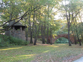
The way the woman's hair flares out in wide, dark "wings" on either side of her shoulders gives her an appearance very similar to that of the statue in Veterans Memorial Park, in the Back Bay Fens.
The female figure in the statue represents Victory (or Winged Victory). The statue was created by John F. Paramino and was erected on this site in 1949 as part of the World War II memorial. The photo at far right shows how it looked in May of 1960.
Note the white, box-shaped structure in front of the statue, toward the middle of the circle. The rim near the top makes it appear from a distance to have a lid. This could be a match for the box in the woman's hands.
The circular WWII memorial in the middle of the memorial park was built in 1949. The Vietnam and Korean war memorials were added later between 1987 and 1990. |
 |
|
||||||||
|
The curved "checkerboard" arch in the lower right corner of the picture might represent an arched stone bridge. There are several of these historic bridges in the Back Bay Fens.
The combination of the arch and the circular tower shown on the box might represent the Riverway bridge and tower shown at far right. There are steps going down from the bridge to the river, so this is one of the places where you can "Face the water / Your back to the stairs." |
 |
|
||||||||
|
The spheres in the image almost certainly represent the large, spherical streetlights found in the Charlesgate area of the Emerald Necklace (see photo at far right). The spheres were opaque, featureless, and connected to their pillars by a thin cylinder.
At a more general level, the spheres could also represent globes and be either a general reference to Columbus or a general reference to Boston, where the main paper is the Boston Globe. Alternatively, they could even be a reference to the Mary Baker Eddy Library and its famous Mapparium, located just a few blocks to the east of Mothers Rest. |
 |
 |
||||||||
 |
||||||||||
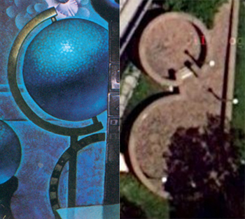
|
The globe and the checkered arch below it appear to form a representation of a circular brick structure in the Charlesgate area (see overhead view at far right). Here's a bird's-eye view of the area looking toward the east.
The structure is known as the "two circles" or "2C" site. It is located on a tiny triangle of land between the Charlesgate offramp and Charlesgate East. According to the Massachusetts Dept. of Conservation and Recreation: The 2C site "was constructed in 1965-1966 as part of the overall construction for the Charlesgate Interchange (aka Bowker Overpass). It was constructed by one of DCR's predecessor agencies, the Metropolitan District Commission (MDC)." |
 |
|||||||||
|
One of the most interesting (and overlooked) features of the image is the floating white surface in the middle of the lower edge. It has a slight ripple, as if to suggest that it isn't a rigid surface like a table, and it doesn't appear to have any thickness at all. It reflects the pole and the edge of the woman's robes, but it does so in a way that deliberately blurs those sharp lines.
More than anything else, this surface resembles sunlit water. Verse 3 tells us that we should end up facing the water, and we know that Palencar incorporated a photo from each hiding spot into each image. Could this be the reflection we should be seeing in Boston?
|
 |
|||||||||
|
The table at lower left in the image is an interesting match for a utility box that once stood in the Charlesgate area beside the "two circles" structure. Note the white surface and the top that extends out over the sides. Most distinctively, note the freeway wall in the background that carries a slender pipe, similar to the ridge that goes across the wall in Image 11.
The box has been removed now, but it can still be seen in Google street views from earlier years. |
 |
 |
||||||||
|
||||||||||
|
The "4" shape in the "window ring" behind the woman is a strikingly good match for the lines that dissect the sidewalk to accommodate the base of a streetlight beside the 2C structure. (The streetlight is a few steps north of the utility box shown above.)
|
 |
|||||||||
|
If this interpretation above is correct, it might mean that all of the lines and cracks on the rim around the circular window represent features of a particular sidewalk. The most likely candidate is the sidewalk just north of the 2C site. |
 |
|||||||||
|
The lower third of the image, below the woman's waist, contains five spheres — two bubbles and three globes. The positioning and size of the globes isn't likely to be random.
We know that Palencar was working from photos taken on the final spot by Preiss, and those photos would show the lamp globes at different sizes, depending on the different distances from the camera. The central and highest globe would be the closest one, followed by the one on the left and then the one on the right.
|
 |
|||||||||
|
The Two Circles site has five spherical street lamps. The computer-generated image at right shows what a person would see if she were standing at the "h" shape in the sidewalk and looking south.
The three streetlights on the right in this view roughly match the size and positioning of the three globes in the image. The remaining two streetlight on the left would be the two (relatively unimportant) bubbles in the image.
This may be a second "Aha Image" that shows what a searcher would see when standing at the final spot. |
 |
|||||||||


Latitude / Longitude Hints
|
The "42" on the woman's cuff could be a reference to the latitude of the greater Boston area, which stretches from 42.2 degrees north to 42.5 degrees north.
The longitude of the greater Boston area ranges from 70.9°W to 71.2°W. No numbers within that range appear in the picture (CONTESTED SEE PANEL BELOW) |
 |
|
The "112" above the flower has led many people to believe that the casque might be in Salt Lake City, Utah (located at 40.7°N 112°W). That interpretation would make it hard to understand the "42" on the cuff.
The unique curved section in her hair right above the flower could also be an upside down 3. If one looks at the "112" upside down, it looks like "711". The 3 is in-line then with 711, making 7113. Boston's rough longitude is west 71.13 (or -71.13). Being upside down could represent that it is negative (or west).
The fact that the 3 is in her hair and not in the flower could represent use in both coordinates. 42.3, -71.13 is a point that lies on the border of the official city of Boston.
Alternatively, the 3 may only apply to the latitude (42). 42.3, -71.1 would then be the implied coordinates. Copley Sq., Boston Public Library, the "Two Circles", the parks within the Fens and some other areas of interest (like Harvard's Medical School) lie within these coordinates (more precisely defined as .01 degrees off these coordinates).
|
|
| Using both the "42" and the "112" as map coordinates is the worst possible solution because 42°N 112°W would place us in remote southeastern Idaho. |
|


Questions, questions, questions...
- Are there any good photos showing what the "Two Circles" structure would have looked like in 1981?
- Does the "Two Circles" structure at Charlesgate Park have an official name? When (and why) was it built? What was its intended purpose?
- Who's going to get the necessary permissions and go dig this thing up?
How to obtain permission for attempted recovery
Assumptions:
Process Status:
Contact info Status:
As of Date:
Contact information:
Name:
Title:
Alternate Contact info:
Permissions Process: