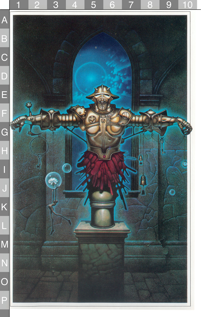
General notes on Image 3
- This is the image for January and the immigration reference is to England.
- This image is thought to be linked to Verse 11 and to a hunt in the vicinity of the Fort Raleigh National Historic Site at the northern end of Roanoke Island, NC.
- The proposed solution for this casque is given on the Image 3 Verse 11 Solution page.
Specific Observations
Please record your notes about this image in the list below. Use the letter/number grid to identify the point on the image that you're describing. To keep things organized, 1) please start each observation with a letter/number combo (in bold), and 2) add new observations in the right place on the list to keep everything alphabetized.
- A3-E8 - The arch is nearly identical to the one at the entrance of the Elizabethan gardens.
- E5 - Some people have suggested that the faceplate of the helmet resembles the face of a horse and may be a hint toward the town of Nags Head, directly across the water from Roanoke Island.
- G1-2 - The underside of the knight's right hand is a really clever reflected representation of the North Carolina coastline. The strange hook hanging from the knight's right wrist represents Albemarle Sound and the bent fingers represent estuaries for the Neuse, Pamlico, and Pungo rivers. (See below for more info.) The fact that this hand extends outside the margin of the picture is probably meant as a clue toward the outer banks.
- G5 - The shape outlined on the breastplate of the armor appears to be a crossbow. There may have been one on display in the visitors center at one time.
- H5 - The jewel is a garnet, the birth stone for January.
- H7 - This bell is very similar to the one on display outside the Paul Revere House in Boston.
- H8 - The crack in the wall may be in the shape of Roanoke Island (see below).
- H9 & I2 - Two skeleton keys are hanging from the suit of armor.
- I10 - The pocket watch hanging from the chain shows a time of 1:00, indicating the month of January.
- J3 - The flower is a white carnation, the birth flower for January.
- J8 - This bell is very similar to a Japanese temple bell on display in the Back Bay Fens of Boston.
- K1-2 - The wall may show the number 54.
- K5 - The cylindrical pedestal under the suit of armor resembles the pedestal under the statue of Virginia Dare at the Elizabethan Gardens.
- L2 - There appears to be a Christian cross carved into the stonework, similar to the cross in the lion's mane in Image 2. If the symbol is connected to the play The Lost Colony, performed at the Waterside Theatre, this might be a reference to the cross used in the baptism scenes. Alternatively, it might refer to the mast and yardarms that move behind the stage as props to represent ships coming and going.
- M8 & M9 - The dangling objects in the lower right corner form a representation of Pear Pad Road, which runs to the northwest corner of the Fort Raleigh National Historic site. The sphere on the spoon represents a traffic circle above the curving road, while the object hanging from the spoon is the "pad" (or flattened stem) of a prickly pear cactus (see below).
- N3 - The object dangling from the foot of the pixie may be a third bell.
- O3 - The pattern of cracks in the floor appears to show the stage of the Waterside Theatre, which features a five-sided structure with a peaked roof and has walls extending out to either side.
- O7-P9 - The wall may show the number 56.
- N3- The object dangling from the woman's foot is probably a plumb bob.
Other Notes
- Please note: The guidelines for The Secret specifically rule out any possibility that a casque could be buried in "any public or private flower bed." That would rule out all of the maintained areas at the Elizabethan Gardens, so please do not do any digging there. We don't want to create problems for the gardeners who maintain that beautiful space. There is also no chance that the casque is buried in any of the undisturbed and archaeologically-significant areas of the historic site, so please do not dig there either. The casque will only be buried in a place where there has already been a great deal of digging and where further digging will not create a problem.
- This figure in the suit of armor may be a representation of the Red Cross Knight, a character is The Faerie Queene by Edmund Spenser.
- The armor shown here may be related in some way to the armor on display in the visitors center at the Fort Raleigh National Historic Site. In particular, the blades seem very similar to those on the halberds in the center's Arms and Armor exhibit:

- The three bells hanging from the armor appear to be a reference to Albert Quentin Bell who designed the Waterside Theatre at the Fort Raleigh National Historic Site. The Waterside Theatre is where The Lost Colony is performed during the summer months. The theatre is still described as "The House that Skipper Bell Built" and there has been a memorial plaque with Albert Bell's name at the back of the theatre since 1967.
- This image has many geometrical connections to Image 11. The two may be connected in some way.
- This is the only image where the contents extend outside the margin.
- These words appear on the Fort Raleigh historical marker:
 |
On this site, in July – August, 1585 (O.S.), colonists, sent out from England by Sir Walter Raleigh, built a fort, called by them “The New Fort in Virginia." These colonists were the first settlers of the English race in America. They returned to England in July, 1586, with Sir Francis Drake. Near this place was born, on the 18th of August, 1587, Virginia Dare, the first child of English Parents born in America – daughter of Ananias Dare and Eleanor White, his wife, members of another band of colonists sent out by Sir Walter Raleigh in 1587. On Sunday, August 20, 1587, Virginia Dare was baptized. Manteo, the friendly Chief of the Hatteras Indians had been baptized on the Sunday preceding. These baptisms are the first known celebrations of a Christian Sacrament in the territory of the thirteen original United States. |
Image Matches
|
The knight's right arm is a reflected representation of the North Carolina coastline, showing many of the major rivers and peninsulas. And the hand extends outside the boundaries of the picture frame because the top of the hand shows the outer banks! (Oh, Palencar, you sneaky devil you!)
Amazingly, no one noticed the connection until wiki user Drumman pointed it out in 2018. You can download the full version of his illustration here. |
 |
|
|
The crack in the wall to the right of the window is in the rough shape of Roanoke Island. This is why readers are told in Verse 11 to go to "the land near the window." |
 |
 |
|
The spoon with a marble in it is a representation of a spoon-shaped service road that appears below a traffic circle in maps of the Fort Raleigh National Historic Site. The service road is named "Pear Pad Road" and the object hanging from the handle of the spoon is the pad (or flattened stem) of a prickly pear cactus.
To the east of Pear Pad Road there is another, larger traffic circle and a large square parking lot used primarily for performances of The Lost Colony. That traffic circle and square parking lot are thought to be the "circle and square" that we are told to pass through in Verse 11. |
 |
 |
 |
 |
|
 |
||
| The suit of armor with the arms outstretched has an interesting resemblance to the figure on the 1980 playbill for The Lost Colony, which is performed every summer at the Waterside Theatre. |
 |
|
| In particular, the shapes formed by the hands have an interesting match to the hands of the figure on the playbill. |
 |
|
|
The outstretched, horizontal arms on the suit of armor are holding up various items (keys, bells, spoons, etc). And the arms are supported from below (in the picture) by diagonal metal bracing that connects from the elbow of each arm down to the torso. Such bracing would be a ridiculous feature in a real suit of armor, of course, because it wouldn't allow the arms to move. Its only purpose would be to allow the arms to support more weight.
Taken together, all of those details suggest that what we are really seeing in Image 3 are boom arms of the kind used in theatrical productions. The arms are attached to vertical truss towers and used to hold sound and lighting equipment. (And the arms are hollow metal pipes, just like the arms of a suit of armor.)
The Waterside Theatre, where The Lost Colony is performed, has at least one such vertical truss tower (with boom arms attached). It is on the western edge of the amphitheatre and the lower half of it is encircled by a fake tree trunk and used to represent the CRO tree at the end of the play. |
 |
|
| On the knight's left breastplate there is a very small four-leaf clover. (Note that there is also a tiny four-leaf clover in Image 11.) |
 |
|
| The Maltese cross was supposed be drawn by the lost Roanoke colonists, should they have to leave because of danger. It was never drawn, and on the right part of the mouth piece/guard there is a design that could fit the cross there. (Perhaps since it wasn't drawn, the cross isn't fully there?) |  |
 |
|
There’s a statue of Virginia Dare in the Elizabethan Gardens with a pedestal resembling the one in the Image 3. Its not an exact match but it is close. |
 |
 |
| The pillar at the bottom of Image 3 highly resembles the one in the picture that stood at the old entrance to Fort Raleigh. As with the previous match, the match is not exact but it is close. |  |
|
Latitude / Longitude Hints
| There appears to be a "36" formed by the cracks in the wall at the lower right corner of the window. |
  |
| There appears to be a "75" formed by the patterns of the cracks in the lower right corner. |
  |
| The northern half of Roanoke Island stretches from approximately 35.89°N, 75.64°W to 35.94°N, 75.73°W. The rounding doesn't really make sense, but the coordinates are very close to the numbers in the picture. |
|
Questions, questions, questions...
- If the bells are a reference to Albert Quentin Bell, what is the symbolism of the keys?
- If the knight is measuring something with his right hand, does that distance match up to anything else?
- Does anyone have a close-up picture of the halberd on display in the Visitor Center at the Fort Raleigh National Historic Site?
- What are the meanings of the bubbles and the statue?
How to obtain permission for attempted recovery
Assumptions:
Process Status:
Contact info Status:
As of Date:
Contact information:
Name:
Title:
Alternate Contact info:
Permissions Process: