General notes on Image 2
- This is the image for April and the immigration reference is to Africa.
- This image is thought to be linked to Verse 6 and a casque in the vicinity of White Point Garden in Charleston, SC. To understand how the clues relate to the landmarks in the park, see our White Point Garden Landmarks page.
- The proposed solution for this casque is given on the Image 2 Verse 6 Solution page.
Specific Observations
Please record your notes about this image in the list below. Use the letter/number grid to identify the point on the image that you're describing. To keep things organized, 1) please start each observation with a letter/number combo (in bold), and 2) add new observations in the right place on the list to keep everything alphabetized.
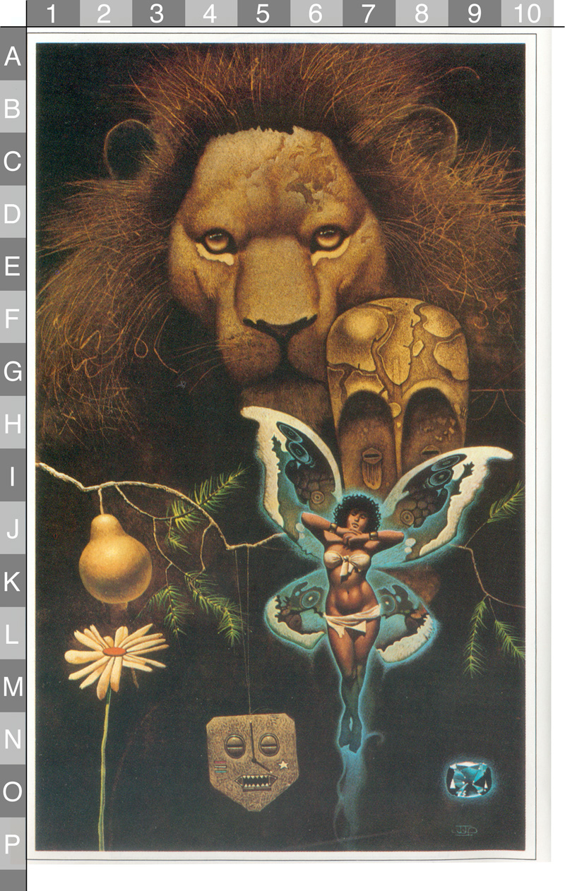
- B3-B7 - There appear to be letters in the lion's mane, possibly spelling "NAVY WAY" or something similar.
- C6 - The "birthmark" on the lion's forehead is almost certainly significant.
- E8 - The number "80" appears in the lion's mane.
- F5 - There may be something written in cursive across the lion's nose.
- F5 to G5 - The "hourglass" shape formed by the black part of the lion's nose may be a reference to the capstan from the Maine.
- F6 to H9 - This appears to be an African Fang mask, possibly modeled on the one on display in the Louvre Museum.
- F9 - The number "36" (or possibly "436" or "+36") appears in the lion's mane.
- G2 - The squiggles in the lion's mane may form a "33" turned sideways.
- G3 - The squiggles here may form a "79" turned upside-down.
- G7/8 - The forehead of the mask shows an outline of the Charleston harbor in South Carolina (see below).
- G7 - Faint line, looks like a streched U
- H1 - There appears to be a Christian cross hidden in the lion's mane, similar to the cross carved in the stonework in Image 3.
- H6-H9/I6-I9 - Looks like possible arches
- H9 - There's a interesting string draped over a stick. Taken together, the stick and string resemble a pair of sunglasses, or a part of a boat mast
- I2 to J5 - The arching pine (fir tree possibly?) branch could represent the curve of Highway 703 as it passes through Mt. Pleasant just east of Charleston.
- J2 - Golden pear. (A possible reference to the Pearman bridge that once crossed the Cooper River from Charleston and connected to Highway 703. The bridge was demolished in 2005.)
- L2 - The flower is a daisy, the birth flower for April.
- L7 - The sash across the woman's hips hangs in an odd shape that appears to represent the USS Amberjack (see below).
- N4 - The pendant (or ornament?) is in the shape of Fort Sumter, which is located in the Charleston harbor (see below).
- N5 - The tall pole and the short shadow in the middle of the "Fort Sumter face" form the long and short hands of an analog clock. The indicated time of 4:00 indicates the month of April. The long "nose" ends in a white tip, possibly making it a reference to White Point Garden.
- O9 - The jewel is a diamond, the birth stone for April. There appear to be two initials in the lower left corner, possibly "TS" or "TF." There are also two white triangles that might represent something.
- P9 - "JJP," the initials of the artist, John Jude Palencar.
Other Notes:
- Because this image is linked to immigration from Africa, the place with the greatest historical significance would be Sullivan's Island, which was a major port for the slave trade carrying Africans to the New World. According to Wikipedia, "Sullivan's Island was also the point of entry for approximately 40 percent of the enslaved Africans brought to British North America, and has been likened to Ellis Island in New York City, New York."
- Sullivan's Island is also the setting for much of Edgar Allen Poe's short story "The Gold-Bug" (written in 1843). Poe spent two years in the Charleston area when he was serving in the U.S. Army at Fort Moultrie between 1827 and 1829. There is now a Poe Avenue that runs by the Fort Moultrie National Monument on Sullivan's Island. The Charleston casque may be related in some way to "The Gold-Bug" or to some other writings by Poe, including "The Cask of Amontillado" (sometimes spelled "The Casque of Amontillado").
- The woman with the wings presumably represents an African immigrant. The butterfly could be based on a number of different species that have eye-like dots on their wings to confuse predators. The butterfly imagery is mentioned on page 17, in the "New Passage" section of the book, where it says that the fairies from Africa "fluttered down, like a windfall of butterflies."
- Several features of the painting (described below) seem to direct us to White Point Garden in downtown Charleston. This blog post gives a good overview of the monuments there. This Imgur photo album gives more close-up pictures of the monuments and features.
- April 2019 Update: An article published in the Charleston Post and Courier on 4/22/19 says that there will be a dig in White Point Garden "early next month." According to the director of the Charleston Parks Department, a team connected to Expedition Unknown will be digging "a small hole, about 2 feet by 2 feet." The article doesn't give any specifics about the location of the hole or the reasoning behind the choice. Stay tuned...
Image Matches
|
The pattern on the forehead of the mask shows a map of the Charleston, South Carolina area. The Charleston peninsula is visible in the middle, with Drum Island beside it. Most of the major waterways are shown.
The narrow arch shown at the tip of the peninsula could be a representation of the major streets in that area. |
  |
|
The bend in the pine branch near the pear could represent the bend in Route 703 (Coleman Blvd) as it passes through Mt. Pleasant just east of Charleston. To the southwest of this bend is Patriots Point, which is one of two departure points for ferries to Fort Sumter.
Prior to its demolition in 2005, the Silas N. Pearman Bridge would have connected at the upper left corner of this map, where Route 703 splits in half to form the on-ramp and off-ramp for the bridge. The bridge passed over Drum Island and connected to the Charleston peninsula. |
  |
|
In the shadows to the right of the mask there is a horizontal pole with a rope draped across it. The combination resembles a pair of sunglasses, but no one has suggested any way that sunglasses might tie in to a solution.
The rope and pole is more likely to be a hint toward the line in Verse 6 about a "bar that binds." The pole would be the bar and the rope would be what gets bound. |
 |
|
The hanging object with a long, thin nose like a flagpole appears to be a representation of Fort Sumter, which has a distinctive five-sided shape. The military connection might explain the star and stripes.
The two lines that go to the "nose" of the pendant may represent the two ferry routes that serve the island, leaving from Liberty Square in Charleston and Patriots Point in Mt. Pleasant.
Note that the shadow from the nose (or flagpole) of the pendant ends in a white point. This might be a hint that we should focus our attention on White Point Garden, a park in downtown Charleston. |
  |
| The sash hanging from the woman's bikini top is a reasonable representation of the shape of White Point Garden, located at the tip of the Charleston peninsula. |
  |
|
The sash wrapped across the woman's hips makes a very unusual and unlikely shape where it hangs. If we flip the image vertically though, we can see that it actualy shows a remarkably clear profile of a ship slicing through the waves.
Given its flat bow and the high conning tower, the ship appears to be a WWII-era Gato-class submarine. These ships were originally built with a smooth wall of armor plating, called a "fairwater," around the conning tower and periscope. The fairwaters proved to be too easily seen by enemies, though, so later ships were built without them and the early ships were retrofitted to have them removed.
The fact that the shape in Image 2 shows a tall fairwater on this submarine means that this is almost certainly the USS Amberjack (SS-219). The Amberjack (shown in a photo at upper right and in a painting below that) was commissioned in June of 1942 and was sunk in February of 1943, before there was a chance for the fairwater to be removed.
The inclusion of this shape in Image 2 is highly significant because White Point Garden includes a memorial to the USS Amberjack. |
 |
|
The patterns and circles in the wing behind the woman form an interesting match for a loggerhead sea turtle. These turtles are thought to live up to 70 years and can grow to be 350 pounds. They visit the Atlantic coastline of southeastern U.S., from Florida to North Carolina, to lay eggs.
The species was declared threatened in 1978 and South Carolina has a conservation program in place to protect it. (Click on image at right to see comparison in more detail.) |
 |
|
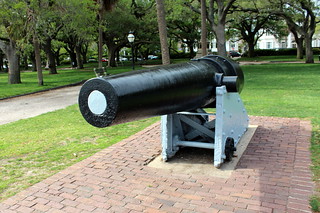
Two of the dots on the butterfly's wings are dark rings with white centers. A similar color pattern can be found in White Point Garden, where the cannons are painted black and the barrels are filled with white plaster.
These cannons could be the "arms extended" that are mentioned in Verse 6. |
  |
|
Most of the larger circles on the butterfly's wings contain smaller circles (as discussed above).
One circle by the woman's head, however, contains a very clear square. And the square is black, suggesting an opening or square-shaped hole. |
 |
|
A line in Verse 6 mentions the "long palm's shadow." The dual meaning of "palm" appears to be emphasized in this image by the crossed palms of the woman's hands that form the shadow of a palm tree on her chest. (Click on image for close-up.)
|
 |
|
The palm shape in Image 2 and the mention of "palm" in Verse 6 could both just be general hints toward South Carolina. According to Wikipedia, "The palmetto has been a symbol for South Carolina since the American Revolutionary War when it was used to build a fort on Sullivan's Island that withstood British attack. The palmetto tree appears on the first symbol of the state, the seal created in 1777. It was officially named the state tree in 1939. It is a very popular state symbol." The South Carolina state flag (shown at right) also features a single palmetto under a crescent moon.
Alternatively, the palm references could be a hint toward a specific palm tree in or near White Point Garden. |
 |
| There appears to be a Christian cross in the lion's mane. This could represent Church Street, which ends at White Point Garden. To see the arrangement of streets in the area, visit our White Point Garden landmarks page. |
 |
|
The diamond in the lower right corner appears to have some white lettering. Possibilities include 75, 7S, TS, and 32 (if turned upside down).
The jewel also has two white triangles that don't seem to match the pattern of that facets. (That is, the tips of those two white triangles do not point in toward the center.) The triangles could be a hint toward the triangular Hobson monument at the corner of Murray and King in White Point Garden. (See our White Point Garden Landmarks page for more information.)
It's possible, in fact, that the whole jewel is meant to be a map corresponding to the rectangular map of White Point Garden. If the larger of the two triangles represents the Hobson monument (#25 on the map at right) then the smaller narrower triangle appears to be pointing at a spot just a little bit inwards from the right edge of the rectangle. That spot would correspond with a location just slightly west of the Maine capstan monument (#8 on the map at right) as proposed on the Image 2 Verse 6 Solution page.
|
|
|
The "birthmark" on the forehead of the lion is almost certainly significant, but no one has managed to find a solid match for the outline so far.
The light/dark contrast forming the shapes seems very similar to the relief sculptures on the base of the Fort Sumter monument in White Point Garden. |
  |


Latitude / Longitude Hints
| There's a "33" in the lion's mane at middle-left. |
 |
Rotated for clarity:
|
| This number initially appears to be a "36," but it could possibly be a "32" with the "2" turned upside-down. There also seems to be a "5" formed using the upper part of the "3," and to the left of that there is either a "+" or a "4." This is (obviously) a difficult number to interpret. |
 |
|
| There's an upside-down "79" close to the lion's whiskers. |
 |
Rotated for clarity: |
| There's an "80" to the right of the lion's eyes. |  |
|
| The tip of the Charleston peninsula is located at 32.8 degrees north and 79.9 degrees west. A range of 79 to 80 degrees for longitude would make sense, but 33 degrees only begins around 20 miles further north and 36 degrees would put one up around the middle of North Carolina. It therefore seems more likely that the "36" is actually a "32" with the second digit turned upside-down. That would create a range of 32 to 33 degrees of latitude, which works for Charleston. The upside-down "2" may have some other significance in the puzzle. |
||

Questions, questions, questions...
- What is the symbolism of the golden pear?
- Why is it on the branch of some conifer?
- Is the arching shape of the branch significant?
Proposed solutions:
- Some bearded hippie sent in a proposed solution involving the "Little Dancer" fountain in White Point Garden.
How to obtain permission for attempted recovery
Assumptions:
Process Status:
Contact info Status:
As of Date:
Contact information:
Name:
Title:
Alternate Contact info:
Permissions Process: