General notes on Verse 11
- This verse is thought to be linked to Image 3 and to a hunt in the vicinity of the Fort Raleigh National Historic Site at the northern end of Roanoke Island, NC.
- The proposed solution for this casque is given on the Image 3 Verse 11 Solution page.
Interpretation
| Lines | Interpretation(s) |
|
Pass two friends of octave |
- Frank and Wilbur Wright were friends with Octave Chanute. The Wright Brothers National Memorial is on the Outer Banks of North Carolina, near Kitty Hawk and Kill Devil Hills. |
| In December | - Take Highway 12. It runs along the east side of the Outer Banks, past Kitty Hawk. |
|
Ride the man of oz |
- "Man of oz" would refer to L. Frank Baum, who wrote The Wizard of Oz. The Washington Baum Bridge connects the Outer Banks to the east side of Roanoke Island. The current bridge was only built in 1994, but there was an earlier bridge in the same place that was dedicated in honor of Washington F. Baum in 1962. (There is also a Thomas Baum Ferry that runs between Hatteras and Ocracoke Islands, but it was only built in 1995. See page 33 of this pdf.) |
| To the land near the window | - "The land near the window" is probably a reference to the outline of Roanoke Island that appears near the window in Image 3. |
|
There's a road that leads to Dark forest |
- After crossing the Washington Baum Bridge, US Highway 64 runs through Manteo and goes to the Fort Raleigh National Historic Site at the northern tip of Roanoke Island. The Elizabethan Gardens are contained entirely within the National Historic Site but are run by a nonprofit group. - The words "dark forest" appear on the Memorial Plaque beside the main entrance to the Elizabethan Gardens (see below). - The words "dark forest" also appear three times in the script for The Lost Colony, the long-running musical drama that is staged every summer at the Waterside Theatre. |
|
Where white is in color With two maps |
- John White (c. 1540 – c. 1593) was an English artist and colonist who was the governor of the colony on Roanoke Island. He is now immortalized as a character in The Lost Colony, which was written by the Pulitzer Prize-winning playwright Paul Green. So "white is in color" could refer to the watercolors painted by John White or it could refer to White being a character in a play by Green. - A sign across from the ticket booth at the entrance to the Waterside Theatre shows two maps. One is a watercolor map by John White and the other is a modern map of the Fort Raleigh National Historic Site. An adjacent sign describes the play and mentions that the play was created by Paul Green. So the spot by the ticket office would work for either interpretation of "where white is in color." - Along the Thomas Hariot Trail at the historic site, there is another sign showing two maps (see below), but there is no obvious explanation of why "white is in color" at that spot. |
|
After circle and square |
- "Circle and square" may refer to the shapes of two garden beds in the Elizabethan Gardens. As shown on the Elizabethan Gardens map, the centerpiece of the area is a large, square bed called the "Sunken Garden" and there are several circular areas around it. Some of these areas, particularly the "Mount and Well Head" may be represented symbolically on the armor in Image 3. - Alternatively, "circle and square" could be a reference to the traffic circle and parking lot that one would drive through to reach the Waterside Theatre (see map below). |
|
In July and August |
- "July and August" may be a reference to the top line of the Virginia Dare Memorial, which begins "On this site, in July-August, 1585." The memorial, however, is outside the Elizabethan Gardens and within the boundaries of the Fort Raleigh National Historic Site. One would pass the memorial on the way from the Visitor Center to the Waterside Theatre. - "July and August" could also be a reference to the summer months when The Lost Colony is performed (although it is usually also performed in June). |
|
A path beckons To mica and driftwood |
- The mention of mica is probably just a general hint to steer searchers to the correct state. According to one blog, "North Carolina is the nation’s leading producer of mica." - The mention of driftwood tells us that we should follow a path north to the coastal edge of the property, where stray logs and branches wash up on the beach. |
|
Under that Which may be last touched Or first seen standing |
- "Last touched or first seen" is almost certainly a reference to a tall tree. When the colonists sailed to Roanoke Island in July of 1587, the first indication of land they would have seen over the horizon would have been the top of a tree. When those colonists disappeared some time later, the last thing they did (apparently) was to peel the bark off the trunks of two trees and carve the letters "CROATOAN" into the trunk of one and "CRO" into the trunk of the other. This was likely to give searchers some idea of where they went. |
|
Look north at the wing And dig To achieve By dauntless and inconquerable Determination Your goal. |
- The instructions that we should "look north ... and dig" strongly suggest that from the actual dig site one should be able to look northwards across the water and see the Wright Brothers National Memorial at Kill Devil Hills. The base of the tower at that memorial bears the phrase "In commemoration of the conquest of the air by the brothers Wilbur and Orville Wright conceived by genius achieved by dauntless resolution and unconquerable faith." - From the northern end of Roanoke Island, both the view from the Elizabethan Gardens and the view from the Waterside Theatre allow one to see the memorial. |
Other Notes:
- To understand the layout of the different features, look at the map of the Fort Raleigh National Historic Site and the map of the Elizabethan Gardens. (If anyone has a physical copy of either map, please photograph it or scan it so we can see it in more detail.)
- Please note: The guidelines for The Secret specifically rule out any possibility that a casque could be buried in "any public or private flower bed." That would rule out all of the maintained areas at the Elizabethan Gardens, so please do not do any digging there. We don't want to create problems for the gardeners who maintain that beautiful space. There is also no chance that the casque is buried in any of the undisturbed and archaeologically-significant areas of the historic site, so please do not dig there either. The casque will only be buried in a place where there has already been a great deal of digging and where further digging will not create a problem.
Image Matches:
|
The Memorial Plaque to the right of the Great Gate of the Elizabethan Gardens Park has the following text:
THE ELIZABETHAN GARDENS DOWN THE CENTURIES, FROM THIS HALLOWED GROUND 1585-1951 |
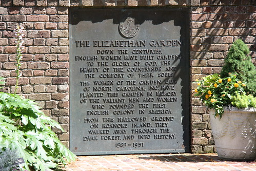 Photo by Mike Moore on Flickr. Used with permission. |
|
This is a map of the Fort Raleigh NHS as it was in 1982. The "1" indicates the location of a set of signs across the path from the ticket booth. One sign features both a watercolor map by John White and a modern map of the Waterside Theatre site. Another sign describes the historical drama The Lost Colony and mentions the playwright Paul Green. This sign may be the spot "Where white is in color / With two maps."
The "July and August" line in the verse has sometimes been linked to the Virginia Dare monument placed in 1896 at the site of the fort (#2 on this map). However, the monument is currently at #3 on the map. Furthermore, it may have been in another location in 1982.
If, however, "July and August" refers to the summer months when The Lost Forest is being staged, then a visitor would enter the "Dark forest" via the park entrance road and pass through a traffic circle before reaching a square parking area. From there, a path leads down to the Waterside Theatre. This would explain why "After circle and square / In July and August / A path beckons / To mica and driftwood."
|
 |
|
This sign comparing two maps is posted along the Thomas Hariot Trail at the Fort Raleigh National Historic Site. The map shown on the left was made 400 years ago by John White, the governor of the colony on Roanoke Island, and the map on the right shows how the same area looks today.
The two maps on the sign could be a match for Line 8 of the verse, but it is hard to see how White is "in color" at this spot. |
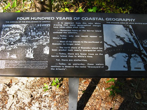
Photo by Jasperdo on Flickr. Used under a Creative Commons license. |
