Synopsis
The casque associated with Image 3 and Verse 11 is (or was) buried on the edge of the Waterside Theatre within the Fort Raleigh National Historic Site at the northern end of Roanoke Island, NC. The coordinates of the most likely burial spot are 35°56'22.0"N 75°42'33.4"W (35.939442, -75.709287).
Detailed steps (from the verse) take us from the Outer Banks of North Carolina over a bridge to Roanoke Island. An outline of the island (from the image) confirms that we are in the right place. A series of instructions (verse) takes us down the path to the Waterside Theatre. A tower made of hollow metal pipes is a symbolic match for the suit of armor (image) and it has symbolism in the play as the tree last touched by the colonists (verse). The casque was buried in the sand at the base of the tower at a spot where one could look across to the wing of the Wright Brothers National Memorial.
Detailed Solution
| The solution given below will present clues from the verse and the image in a way that narrows down the search area to that specific point. Bits of the original image are shown in the left column in cells with a tan background. Lines from the verse are in the same column but with a yellow background. (For more detail about any particular clue, check the page for the image or verse.) | ||
| Clues | Interpretations | |
 |
 |
Cracks in the lower right corner of the wall appear to form a "36" and a "75." The intersection of 36 degrees north and 75 degrees west is in the Atlantic, just off the eastern coast of North America.
The nearest dry land, just a few miles to the west of those coordinates, is at Kill Devil Hills on the Outer Banks (a string of barrier islands off the North Carolina coast). |
 |
 |
|
|
1) Pass two friends of octave |
Frank and Wilbur Wright are generally credited as being the inventors of the modern airplane and they were friends with Octave Chanute. Our landfall at Kill Devil Hills puts us at the spot where the first heavier-than-air powered flight took place: the Wright Brothers National Memorial (coordinates 36.0°N and 75.7°W).
|
|
|
2) In December
|
The road that runs outside the Wright brothers memorial is Highway 12. If we are to "pass" the memorial "in December," we are meant to take the highway either north or south. (The horse-like faceplate on the suit of armor may be intended as a hint toward the town of Nags Head, which one would pass through on Hwy. 12 heading south.)
|
|
 |
||
|
3) Ride the man of oz
|
"Man of oz" would refer to L. Frank Baum, who wrote The Wizard of Oz. Many searchers have mistakenly interpreted this line as a reference to the Thomas Baum Ferry that runs between Hatteras and Ocracoke Islands, but that ferry was only built in 1995.
The correct reference is to the Washington Baum Bridge that connects the Outer Banks to the east side of Roanoke Island. The bridge that is currently in place was only built in 1994, but an earlier bridge in the same place (and with the same name) was built and dedicated in 1962. A highway sign (shown at left) makes the name clear to anyone driving over the bridge.
|
|
|
|
||
|
4) To the land near the window
|
"The land near the window" refers to the outline of Roanoke Island that appears near the window in Image 3. (Yes, it's an abstract representation, just like every other visual clue in The Secret.)
Together, Lines 3 & 4 are telling us to turn off Route 12 and take the Washington Baum Bridge to Roanoke Island. |
|
 |
||
|
5) There's a road that leads to 6) Dark forest
|
After crossing the Washington Baum Bridge, US Highway 64 runs through Manteo and goes to the Fort Raleigh National Historic Site at the northern tip of Roanoke Island.
The words "dark forest" have multiple connections to the area around the historic site. They appear on the Memorial Plaque beside the main entrance to the Elizabethan Gardens (see left). They also appear three times in the script for The Lost Colony, the long-running musical drama that is staged every summer at the Waterside Theatre.
These lines confirm we are in the correct general area. |
|
 |
||
|
Our route so far:
|
||
|
Now that we are at the northern tip of Roanoke Island, it's worth stopping to list the many places where a casque could not be buried:
Combining all of those restrictions eliminates more than 95% of the northern tip of Roanoke Island and narrows our search considerably. We are now looking for a relatively sheltered place where we can dig beside some distinctive, man-made object without damaging any flowerbed, grave site, or archeologically-important area. Onwards...
|
||
|
7) Where white is in color 8) With two maps |
John White (c. 1540 – c. 1593) was an English artist and colonist who was the governor of the colony on Roanoke Island. He is now immortalized as a character in The Lost Colony, which was written by the Pulitzer Prize-winning playwright Paul Green. So "white is in color" could refer to the watercolors painted by John White or it could refer to White being a character in a play by Green.
|
|
 |
Up until very recently, a sign across from the ticket booth at the entrance to the Waterside Theatre showed two maps. One was a historic watercolor map by John White and the other was a modern map of the Fort Raleigh National Historic Site. An adjacent sign described the play and mentioned that the play was created by Paul Green. So the spot by the ticket office would have worked for either interpretation of "where white is in color."
|
|
|
9) After circle and square |
"Circle and square" refers to the traffic circle and parking lot that one would drive through to reach the ticket booth for the Waterside Theatre. Note that the modern map shown in the upper right corner of the ticket booth sign makes these shapes very clear. (The map also gives a clear outline to the shape of Pear Pad Road, which is also represented in Image 3.)
|
|
|
10) In July and August |
We know that Byron Preiss liked to make fanciful historical connections, and this line may be one of them. "July and August" is a quotation from the top line of the Virginia Dare Memorial, which begins "On this site, in July-August, 1585." The memorial is on the grounds of the Fort Raleigh National Historic Site and one would pass it on the way from the Visitor Center to the Waterside Theatre.
"July and August" are also two summer months when The Lost Colony is performed. Visitors in the modern world coming to see the performances would pass through the circle and square and see the sign with the two maps.
|
|
|
11) A path beckons 12) To mica and driftwood |
The mention of mica is probably just a general hint to steer searchers to the correct state. According to one blog, "North Carolina is the nation’s leading producer of mica."
The mention of driftwood tells us that after circle, square, and two maps we should follow a path that leads in the direction of the beach and Roanoke Sound.
|
|
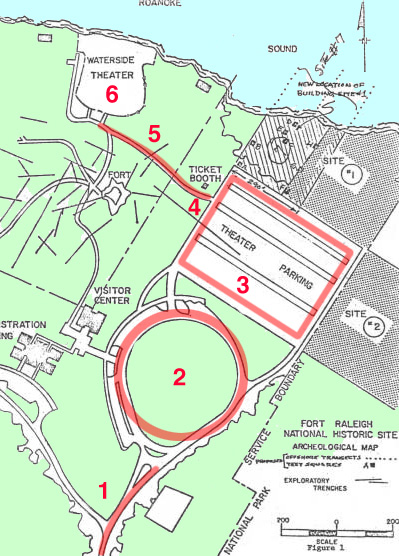 |
Here are those same steps shown in the order in which they would occur. The underlying map is from a 1982 NPS planning document and should show things exactly as they would have been when Preiss was there.
1 - The "road that leads to dark forest" (the entrance road from US Highway 64).
2 - "Circle" (the traffic circle beside the Visitors Center).
3 - "Square" (the parking lot for the theater).
4 - The ticket booth where white is (or was) in color with two maps. Tickets for performances of The Lost Colony are sold here in July and August.
5 -The trail to the Waterside Theatre. It leads in the direction of Roanoke Sound and the beach (where there would be driftwood). It was the only trail from the ticket booth.
6 - The Waterside Theatre. |
|
 |
 |
The Waterside Theatre is a V-shaped outdoor auditorium on the northern tip of Roanoke Island. It has two banks of seats with a curving aisle running between them. Just behind the stage, the shoreline spreads out on either side.
Image 3 is showing us all those same features in a set of cracks that are centrally located on the wall. There is the V-shaped auditorium, divided by the aisle, and the shoreline spreading out to either side behind the tip of the V. |
 |
 |
The Waterside Theatre was originally built in 1936 by an Englishman named Albert Bell, who was known as "Skipper." When a fire broke out and burned most of the theatre in 1947, Bell quickly rebuilt it. And after Hurricane Donna destroyed most of the theatre in 1960, Bell was in charge of rebuilding it yet again.
The history of the Waterside Theatre is so closely tied to this one individual that it is commonly known as "The House that Skipper Bell Built." The placement of bells beside the outline of Roanoke Island in Image 3 strongly makes the connection and could lead searchers directly to the Waterside Theatre even without all the other clues prior to this point. |
 |
After Bell's death in 1964, a plaque was installed in his memory at Waterside Theatre. The plaque has a prominent place where one enters the theatre and it is the first thing one would see at the end of the path from the ticket booth.
Even a visitor unfamiliar with the history of the theatre could see the name "Bell" at this spot and make the connection. |
|
|
|
Anyone who has ever seen a performance of The Lost Colony would likely get a sense of recognition on seeing the cracks of the floor in the lower left corner of the image. The stage at the Waterside Theatre has always featured a five-sided house structure in the middle of the back wall. The highest point of the structure forms the tip of the peaked roof. The two lowest points meet the floor of the stage. And the two remaining points of the pentagon are where horizontal roofs of sheds or other structures extend out to each side.
The cracks in the floor capture that same basic structure, with the pentagonal shape of the house meeting the horizontal lines of the stage and the sheds. But the illustration only shows us the western half of the symmetrical structure. We are seeing "stage right" (or "house left" from the audience's point of view). The bell extending down to the diagram seems to be pointing, drawing our attention to that part of the stage.
The side of the stage shown in the cracks plays a significant part in the performances of The Lost Colony. At the end of the play, as the colonists go away, the actors troop off that end of the stage and go up a short ramp to a landing on the side before exiting.
|
|
 |
Let us pause now and take another look at the central figure of Image 3. We have a central suit of armor with arms outstretched (and propped up). The suit of armor is a metal structure and the outstretched arms are hollow metal cylinders. They are essentially pipes. And each arm is being used to hang various objects.
|
|
 |
Looking around the theatre, we can see a structure that is, in a somewhat abstract or metaphorical way, similar to the Image 3 suit of armor. On the western edge of the auditorium there is an upright metal tower with outstretched pipes. The pipes are fastened in place and are used to rig lights and other equipment for performances. They are essentially outstretched metal arms used for hanging things.
|
|
|
13) Under that 14) Which may be last touched 15) Or first seen standing |
"Last touched or first seen" is almost certainly a reference to a tall tree. When the colonists sailed to Roanoke Island in July of 1587, the first indication of land they would have seen over the horizon would have been the top of a tree. When those colonists disappeared some time later, the last thing they did (apparently) was to peel the bark off the trunks of two trees and carve the letters "CROATOAN" into the trunk of one and "CRO" into the trunk of the other. This was likely to give searchers some idea of where they went.
The CRO tree has enormous symbolic and emotional importance, both in the play The Lost Colony and in the history of Roanoke Island.
|
|
 |
For performances of The Lost Colony, the crew builds a new "CRO tree" every year. It is always on the western edge of the auditorium on a small landing, so the cast can assemble there and touch it before they parade out.
This picture shows how the CRO tree looked in 2011. Photo by Sarah Stierch (CC BY 4.0). |
|
 |
So where does the crew build the CRO tree for The Lost Colony? You guessed it!
The structure around which they build the CRO tree every year is... the same metal tower with outstretched arms. This picture shows how the tower and tree look in early summer of 2017.
|
|
|
16) Look north at the wing 17) And dig 18) To achieve 19) By dauntless and inconquerable 20) Determination 21) Your goal. |
The instructions that we should "look north ... and dig" strongly suggest that from the actual dig site one should be able to look northwards across the water and see the Wright Brothers National Memorial at Kill Devil Hills. The memorial feature a large wing-shaped monument that is visible from a long ways across the water. And the dedication at the base of that wing bears the phrase "In commemoration of the conquest of the air by the brothers Wilbur and Orville Wright conceived by genius achieved by dauntless resolution and unconquerable faith."
|
|
 |
 |
If you are standing beside the CRO tree on the landing, at the western edge of the auditorium, you will be elevated enough to have an unobstructed view over the stage and props and wall. You can see the wing of the Wright Brothers Memorial as a white dot on the horizon. (A view across the water at higher resolution is available here.) |
 |
 |
Beneath the suit of armor in Image 3 there is a pedestal with cracks. Most of the cracks are hazy and indistinct, but there's one section that is sharper and clearer than that rest. That section seems to show a forking path with a small square in the fork.
Aerial views show a similar set of paths at the northwest corner of the Waterside Theatre. There is a path from the stage with a broad area beside it and then a small square where the path and wider area meet. And that small square is the landing where the CRO tree and tower are located.
And that's where the casque was buried. It is (or was) under the CRO tree, the representation of "that which may be last touched" by the unfortunate colonists of the Lost Colony. |
|
Final Location: 35°56'22.0"N 75°42'33.4"W(Latitude: 35.939442, Longitude: -75.709287)
|
||


But what about the wooden floor?
People who have visited the Waterside Theatre have reported back that the tiny stage around the CRO tree is actually a wooden platform covered by a couple of inches of loose sand. So what gives? Preiss obviously didn't dig through the floorboards, so does that rule out this solution? Well... not necessarily.
The vertical truss carries some serious weight and it obviously wasn't just installed by jabbing it into the sand. There must be a cylinder of concrete formed from a sonotube at the base. (And that cylinder may once have been visible, explaining the vertical cylinder under the suit of armor.) Other than that, the only structure that would have been necessary in the spot would be a low retaining wall on the north side to keep the patch of sand level.
This is all just conjecture, but it's possible that the retaining wall was all that was holding the sand in place in 1980. Preiss was able to visit the platform and bury the casque in the loose sand in front of the CRO tree. And then, sometime later, actors may have complained that they were risking a twisted ankle every time they stepped off the solid stage and solid path to do that final scene in the sand. So, in one of the many renovations that have occurred over the past 40 years, the theatre added a wooden floor to the platform. The floor would give a stable footing and have the added benefit of elevating the actors to make that final scene more visible to the audience. That may also have been the change that hid the sonotube-cast concrete.
This is all just a theory, of course, but if the wooden flooring was added later (post-1982) it's quite possible that it has entombed the casque in the sand below it, keeping the casque safe but also keeping it from being found. Please, please, please do not go cutting through the CRO tree stage to find out! If the casque is still there, it's safe and not going anywhere. It will be found someday, when the Waterside Theatre does its next major renovation.
Other Notes:
- Just as with all the other puzzles, Image 3 includes a few visual references to features at various distances from the final hiding spot. The suit of armor includes various weapons found in the Fort Raleigh Visitors Center (including a crossbow and a halberd). A spoon holding a pea forms the shape of Pear Pad Road (with a pear pad dangling from the spoon as confirmation). The pedestal under the suit of armor may or may not include features of statues in the Elizabethan Gardens. For details on these and other matches, see the Image 3 page. These features are all included partly as red herrings and partly to confirm that we are in the right general area. But the complete solution, as always, relies on combining the image and the verse.
- Because of the historical nature of the site, any attempt to recover the casque will be very challenging and will require the permission and active participation of the Roanoke Island Historical Association and possibly the National Park Service. Please keep in mind that there is no chance that the casque is buried in any of the undisturbed and archeologically-significant areas of the historic site, so please do not dig there. The casque will only be buried in a place where there has already been a great deal of digging and where further digging will not create a problem.
- Note that the final hiding spot meets all the conditions outlined above. It is not in any undisturbed area with archeological significance. It's not in or near any flower bed or cemetery. It's protected from disturbance by storms, but it still has open soil for digging. (You chose a good spot, Byron Preiss! Good work!)
- So is the casque still there? Unlikely, but it's hard to say for sure. Page 79 of the Fort Raleigh National Historic Site Administrative History says that the audience area of the amphitheater underwent a major renovation in the 1990's after "the theater’s condition had entered a noticeable state of decline." It's hard to imagine that such a renovation wouldn't include replacing the pilings that hold up the ramp and landings on the west side of the theatre. If those pilings were replaced, the casque may well have been exposed and/or destroyed. But, at the moment, we have no way of knowing for sure.
- For more information about the 1997 renovation of the Waterside Theatre, see “Waterside Theatre to Be Renovated” on page 7 of Roanoke Colonies Research Newsletter, Vol. 4, No. 1 (November 1996).
- If you're in the area and want to attempt a casque recovery, the first step will probably be to get the participation of the Roanoke Island Historical Association. Be sure to be a responsible searcher and do no harm. Good luck!