| The solution given below will present clues from the verse and the image in a way that narrows down the search area to that specific point. Bits of the original image are shown in the left column in cells with a tan background. Lines from the verse are in the same column but with a yellow background. (For more detail about any particular clue, check the page for the image or verse.) |
| Clues |
Interpretations |
 |

|
Cracks in the lower right corner of the wall appear to form a "36" and a "75." The intersection of 36 degrees north and 75 degrees west is in the Atlantic, just off the eastern coast of North America.
The nearest dry land, just a few miles to the west of those coordinates, is at Kill Devil Hills on the Outer Banks (a string of barrier islands off the North Carolina coast).
|
 |

|
|
1) Pass two friends of octave
|
Frank and Wilbur Wright are generally credited as being the inventors of the modern airplane and they were friends with Octave Chanute. Our landfall at Kill Devil Hills puts us at the spot where the first heavier-than-air powered flight took place: the Wright Brothers National Memorial (coordinates 36.0°N and 75.7°W).
|
|
2) In December
|
The road that runs outside the Wright brothers memorial is Highway 12. If we are to "pass" the memorial "in December," we are meant to take the highway either north or south. (The horse-like faceplate on the suit of armor may be intended as a hint toward the town of Nags Head, which one would pass through on Hwy. 12 heading south.)
|
 |
|
3) Ride the man of oz
|
"Man of oz" would refer to L. Frank Baum, who wrote The Wizard of Oz. Many searchers have mistakenly interpreted this line as a reference to the Thomas Baum Ferry that runs between Hatteras and Ocracoke Islands, but that ferry was only built in 1995.
The correct reference is to the Washington Baum Bridge that connects the Outer Banks to the east side of Roanoke Island. The bridge that is currently in place was only built in 1994, but an earlier bridge in the same place (and with the same name) was built and dedicated in 1962. A highway sign (shown at left) makes the name clear to anyone driving over the bridge.
|
|

|
|
4) To the land near the window
|
"The land near the window" refers to the outline of Roanoke Island that appears near the window in Image 3. (Yes, it's an abstract representation, just like every other visual clue in The Secret.)
Together, Lines 3 & 4 are telling us to turn off Route 12 and take the Washington Baum Bridge to Roanoke Island.
|
 |
|
5) There's a road that leads to
6) Dark forest
|
After crossing the Washington Baum Bridge, US Highway 64 runs through Manteo and goes to the Fort Raleigh National Historic Site at the northern tip of Roanoke Island.
The words "dark forest" have multiple connections to the area around the historic site. They appear on the Memorial Plaque beside the main entrance to the Elizabethan Gardens (see left). They also appear three times in the script for The Lost Colony, the long-running musical drama that is staged every summer at the Waterside Theatre.
These lines confirm we are in the correct general area.
|
 |
|
Our route so far:

|
|
Now that we are at the northern tip of Roanoke Island, it's worth stopping to list the many places where a casque could not be buried:
- Most of the northern tip of the island is contained inside the Fort Raleigh National Historic Site. The area has enormous historical significance because it's where the Roanoke Colony was established by Sir Walter Raleigh in 1587. Archeological digs have been taking place within the historic site for decades and Preiss was clearly well aware of the land's history and importance. There is absolutely no chance that he would have disturbed a pristine natural area where artifacts might be found. He wouldn't be digging in any wooded or natural areas, and modern searchers shouldn't dig there either.
- The other big chunk of land at the tip of the island contains the privately-owned Elizabethan Gardens. The guidelines for The Secret specifically rule out any possibility that a casque could be buried in "any public or private flower bed." On top of that, it's extremely unlikely that Preiss expected us to pay admission, smuggle a shovel in our pants past a gatekeeper, and then dig in a formal garden. Image 3 may have visual hints to some features in the gardens, but we can rule out that entire plot of land as a hiding place.
- The guidelines for The Secret also specifically say that no casques will be buried in any cemeteries, so we can rule out the small graveyard at the end of Pear Pad Road.
- The coastline of Roanoke Island is constantly reshaped by storms, and it's very unlikely that Preiss would bury a plexiglass box on a beach where shifting sands could quickly leave it uncovered. Any spot that's directly exposed to high waves from the ocean is not a realistic possibility. (Plus, we know from other solutions that there should always be a distinctive man-made object very near the casque, and there are no such features on the beach.)
- And (obviously) the casque could not be in a building or underneath a paved road or parking lot.
Combining all of those restrictions eliminates more than 95% of the northern tip of Roanoke Island and narrows our search considerably. We are now looking for a relatively sheltered place where we can dig beside some distinctive, man-made object without damaging any flowerbed, grave site, or archeologically-important area. Onwards...
|
|
7) Where white is in color
8) With two maps
|
John White (c. 1540 – c. 1593) was an English artist and colonist who was the governor of the colony on Roanoke Island. He is now immortalized as a character in The Lost Colony, which was written by the Pulitzer Prize-winning playwright Paul Green. So "white is in color" could refer to the watercolors painted by John White or it could refer to White being a character in a play by Green.
|
 |
Up until very recently, a sign across from the ticket booth at the entrance to the Waterside Theatre showed two maps. One was a historic watercolor map by John White and the other was a modern map of the Fort Raleigh National Historic Site. An adjacent sign described the play and mentioned that the play was created by Paul Green. So the spot by the ticket office would have worked for either interpretation of "where white is in color."
|
|
9) After circle and square
|
"Circle and square" refers to the traffic circle and parking lot that one would drive through to reach the ticket booth for the Waterside Theatre. Note that the modern map shown in the upper right corner of the ticket booth sign makes these shapes very clear. (The map also gives a clear outline to the shape of Pear Pad Road, which is also represented in Image 3.)
|
|
10) In July and August
|
We know that Byron Preiss liked to make fanciful historical connections, and this line may be one of them. "July and August" is a quotation from the top line of the Virginia Dare Memorial, which begins "On this site, in July-August, 1585." The memorial is on the grounds of the Fort Raleigh National Historic Site and one would pass it on the way from the Visitor Center to the Waterside Theatre.
"July and August" are also two summer months when The Lost Colony is performed. Visitors in the modern world coming to see the performances would pass through the circle and square and see the sign with the two maps.
|
|
11) A path beckons
12) To mica and driftwood
|
The mention of mica is probably just a general hint to steer searchers to the correct state. According to one blog, "North Carolina is the nation’s leading producer of mica."
The mention of driftwood tells us that after circle, square, and two maps we should follow a path that leads in the direction of the beach and Roanoke Sound.
|
|
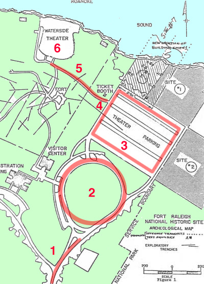
Here are those same steps shown in the order in which they would occur. The underlying map is from a 1982 NPS planning document and should show things exactly as they would have been when Preiss was there.
1 - The "road that leads to dark forest" (the entrance road from US Highway 64).
2 - "Circle" (the traffic circle beside the Visitors Center).
3 - "Square" (the parking lot for the theater).
4 - The ticket booth where white is (or was) in color with two maps. Tickets for performances of The Lost Colony are sold here in July and August.
5 -The trail to the Waterside Theatre. It leads in the direction of Roanoke Sound and the beach (where there would be driftwood). It was the only trail from the ticket booth.
6 - The Waterside Theatre.
|
 |
 |
The Waterside Theatre is a V-shaped outdoor auditorium on the northern tip of Roanoke Island. It has two banks of seats with a curving aisle running between them. Just behind the stage, the shoreline spreads out on either side.
Image 3 is showing us all those same features in a set of cracks that are centrally located on the wall. There is the V-shaped auditorium, divided by the aisle, and the shoreline spreading out to either side behind the tip of the V.
|
 |
 |
The Waterside Theatre was originally built in 1936 by an Englishman named Albert Bell, who was known as "Skipper." When a fire broke out and burned most of the theatre in 1947, Bell quickly rebuilt it. And after Hurricane Donna destroyed most of the theatre in 1960, Bell was in charge of rebuilding it yet again.
The history of the Waterside Theatre is so closely tied to this one individual that it is commonly known as "The House that Skipper Bell Built." The placement of bells beside the outline of Roanoke Island in Image 3 strongly makes the connection and could lead searchers directly to the Waterside Theatre even without all the other clues prior to this point.
|
 |
After Bell's death in 1964, a plaque was installed in his memory at Waterside Theatre. The plaque has a prominent place where one enters the theatre and it is the first thing one would see at the end of the path from the ticket booth.
Even a visitor unfamiliar with the history of the theatre could see the name "Bell" at this spot and make the connection.
|
|


|
Anyone who has ever seen a performance of The Lost Colony would likely get a sense of recognition on seeing the cracks of the floor in the lower left corner of the image. The stage at the Waterside Theatre has always featured a five-sided house structure in the middle of the back wall. The highest point of the structure forms the tip of the peaked roof. The two lowest points meet the floor of the stage. And the two remaining points of the pentagon are where horizontal roofs of sheds or other structures extend out to each side.
The cracks in the floor capture that same basic structure, with the pentagonal shape of the house meeting the horizontal lines of the stage and the sheds. But the illustration only shows us the western half of the symmetrical structure. We are seeing "stage right" (or "house left" from the audience's point of view). The bell extending down to the diagram seems to be pointing, drawing our attention to that part of the stage.
The side of the stage shown in the cracks plays a significant part in the performances of The Lost Colony. At the end of the play, as the colonists go away, the actors troop off that end of the stage and go up a short ramp to a landing on the side before exiting.
|
 |
Let us pause now and take another look at the central figure of Image 3. We have a central suit of armor with arms outstretched (and propped up). The suit of armor is a metal structure and the outstretched arms are hollow metal cylinders. They are essentially pipes. And each arm is being used to hang various objects.
|
 |
Looking around the theatre, we can see a structure that is, in a somewhat abstract or metaphorical way, similar to the Image 3 suit of armor. On the western edge of the auditorium there is an upright metal tower with outstretched pipes. The pipes are fastened in place and are used to rig lights and other equipment for performances. They are essentially outstretched metal arms used for hanging things.
|
|
13) Under that
14) Which may be last touched
15) Or first seen standing
|
"Last touched or first seen" is almost certainly a reference to a tall tree. When the colonists sailed to Roanoke Island in July of 1587, the first indication of land they would have seen over the horizon would have been the top of a tree. When those colonists disappeared some time later, the last thing they did (apparently) was to peel the bark off the trunks of two trees and carve the letters "CROATOAN" into the trunk of one and "CRO" into the trunk of the other. This was likely to give searchers some idea of where they went.
The CRO tree has enormous symbolic and emotional importance, both in the play The Lost Colony and in the history of Roanoke Island.
|
 |
For performances of The Lost Colony, the crew builds a new "CRO tree" every year. It is always on the western edge of the auditorium on a small landing, so the cast can assemble there and touch it before they parade out.
This picture shows how the CRO tree looked in 2011. Photo by Sarah Stierch (CC BY 4.0).
|
 |
So where does the crew build the CRO tree for The Lost Colony? You guessed it!
The structure around which they build the CRO tree every year is... the same metal tower with outstretched arms. This picture shows how the tower and tree look in early summer of 2017.
|
|
16) Look north at the wing
17) And dig
18) To achieve
19) By dauntless and inconquerable
20) Determination
21) Your goal.
|
The instructions that we should "look north ... and dig" strongly suggest that from the actual dig site one should be able to look northwards across the water and see the Wright Brothers National Memorial at Kill Devil Hills. The memorial feature a large wing-shaped monument that is visible from a long ways across the water. And the dedication at the base of that wing bears the phrase "In commemoration of the conquest of the air by the brothers Wilbur and Orville Wright conceived by genius achieved by dauntless resolution and unconquerable faith."
|
 |
 |
If you are standing beside the CRO tree on the landing, at the western edge of the auditorium, you will be elevated enough to have an unobstructed view over the stage and props and wall. You can see the wing of the Wright Brothers Memorial as a white dot on the horizon. (A view across the water at higher resolution is available here.) |
 |
 |
Beneath the suit of armor in Image 3 there is a pedestal with cracks. Most of the cracks are hazy and indistinct, but there's one section that is sharper and clearer than that rest. That section seems to show a forking path with a small square in the fork.
Aerial views show a similar set of paths at the northwest corner of the Waterside Theatre. There is a path from the stage with a broad area beside it and then a small square where the path and wider area meet. And that small square is the landing where the CRO tree and tower are located.
And that's where the casque was buried. It is (or was) under the CRO tree, the representation of "that which may be last touched" by the unfortunate colonists of the Lost Colony.
|
|
Final Location: 35°56'22.0"N 75°42'33.4"W
|


Comments (33)
T54 said
at 2:57 pm on Feb 5, 2018
Wow you guys cracked it! Sorry I haven't been on in a while. Life things and such. This solution sounds very plausible however how realistic is it do you think that he berried it where you say he berried it. That spot looks very public.
manteo said
at 8:10 pm on Feb 6, 2018
I think there is little doubt that this treasurer was buried on Roanoke Island. The theory about it being buried under the fiberglass Croatoan tree is suspect, as the tree was first created in 2010. Prior to that, the Croatoan sign was hanging on a tree near where the fiberglass tree is now, but the location varied over the years, and I have not been able to find a photo of where it was in 1981. My best guess is that Preiss buried it next to the old watergate of the Elizabethan Gardens, as the iron gate that was at that location in the early 80s had a strong resemblance to the armor. Once I figure out how, I'll post some photos of it. The red sword-like skirt around the armor's waist probably was meant to refer to the yucca plants at the base of the stone pillars the gate hung from. There also is a brochure of the Eliz Gardens from 1981 which has a map on which a path leading to the watergate looks remarkably like the reversed image of the gnome hanging from the armor, and which also talks about Mr. Bell being one of the people who was instrumental in designing the planting for the gardens. And, the watergate would be the first thing seen if you arrived at the gardens from the water, and the gate would be the last thing touched as you left the gardens in that direction. Also, the strange form hanging horizontally from the armors right arms looks just like the latch on the old watergate. Unfortunately, there have been several hurricanes since 1981, two of which have washed all of the ground away from all sides of the gate, and one which collapsed the gate into the water. If the treasure was buried there, it is long gone. On a side note, they did recently use ground-penetrating radar all around the existing gate, and did a dig there, and found nothing. I think this treasure is lost for good, unless someone finds it on the bottom of Roanoke sound.
Chris314 said
at 3:55 pm on Feb 19, 2018
Hi, I'm a theatre dork. A free standing structure that lights are hung off of is frequently known as a "lighting tree." Something as big as this one might be more likely to be called a tower, but it's a connection that is worth pointing out. While it would be really awesome if the casque was under the fiberglass tree, I think the riddle can still work without it. I have some friends who have been in the outdoor drama, and am in the process of reaching out to them for more information about what that area was like before the recent renovations and what traditions they had back in 1981.
Brad Hodges said
at 11:07 pm on Feb 19, 2018
My wife and I are going to visit the island very soon and see what we can figure out in person. Anyone have any contacts within the historic society?
James said
at 1:47 pm on Feb 20, 2018
Brad, when do you plan to go there?
Brad Hodges said
at 2:42 pm on Feb 20, 2018
In a few weeks
James said
at 1:31 pm on Feb 23, 2018
Let me know if you would like to meet up there.
Brad Hodges said
at 7:34 pm on Feb 23, 2018
Do you have a contact for the historical society?
James said
at 6:22 pm on Feb 26, 2018
Not yet. Have talked to some people that I know in the area who are trying to find out who is in it.
Brad Hodges said
at 9:02 pm on Feb 23, 2018
Has anyone else actually proded , dug in the area proposed in the solution?
Oregonian said
at 10:20 am on Feb 25, 2018
People have poked around at the base of the lighting tower, but that seems pointless (and dangerous) to me. There are obviously going to be underground wires in that spot and there's no way Preiss would have us digging there.
The place to be looking is out at the corner of the platform. There are wooden support walls on two sides there, keeping the platform elevated above the path, and so there shouldn't be anything at all in the top two feet of soil (because there's no place for the wires to go). Any wiring running from the tower toward the seats or toward the stage would need to already be three feet deep at that spot to pass under the retaining walls and the path.
T54 said
at 11:37 am on Feb 26, 2018
OK question, isn't the theater private land?
Oregonian said
at 7:48 pm on Feb 26, 2018
No, the Waterside Theatre is actually part of the Fort Raleigh National Historic Site and is owned by the National Park Service (NPS). A private group, the Roanoke Island Historical Association (RIHA), uses the theatre to put on "The Lost Colony."
"The Lost Colony is the nation’s longest-running outdoor symphonic drama (over 70 years) and is housed within buildings and on land owned by the NPS. The NPS is responsible for maintenance and upkeep. The relationship between the NPS and RIHA is legislated by the 1941 order that established the park. Park management is currently working with RIHA to redefine an expired formal agreement."
https://www.nps.gov/hfc/pdf/ip/2010-05-14-FORA-FinalDocument.pdf
James said
at 3:18 pm on Feb 27, 2018
I now have contact information for someone at the Outer Banks History Center. What should I say or not say in regards to obtaining contact information for someone at the Roanoke Island Historical Association?
James said
at 5:13 pm on Mar 3, 2018
Recently spoke with someone from the RIHA. The theater and the area around it are all NPS, (everyone here probably already knew that), and would require pre-approval from the NPS, obviously.
Brad Hodges said
at 9:44 pm on Mar 18, 2018
We visited the park for 3 days last week. Whoever said they dug at the CRO were either mistaken or fibbing. The tree is built around a metal frame that is standing on a wooden platform that is built above the ground by about 1 foot. The sand or dirt you see is a very thin layer just to cover the wood. Someone would have to crawl under the very small crawl space to actually dig under the tree. Also, you cannot see the Wright Brother monument from where the CRO tree is. I did a full breakdown on the Shhh The Secret ‘s podcast Facebook Roanoke group page including tons of photos and some videos for anyone who is interested. The theatre and the rest of the park is not monitored. It is 100% open for anyone to visit 24/7. Just be respectful in your imvestigation and don’t go digging holes without permission. If you just can’t help yourself, do so carefully and fill them back in. Our solves are either at the end of Colony Walk (part of the Elizabethan Gardens but accessible from the beach) or a very nice bench area that another path dead ends at facing the beach. Both of the places are documented in my photos/videos. If it was at the gate, it is long gone as that area experienced severe errosion from a storm three weeks ago and the sand is now gone 5 1/2 feet down from where it used to be.
Don said
at 6:51 pm on Feb 18, 2023
My proposed solution is at:
https://www.academia.edu/97130038/The_Secret_proposed_solution_Kill_Devil_Hills_North_Carolina
Emily Schuman said
at 1:34 pm on Mar 5, 2023
If you follow the directions to the theater, the show starts with all the actors standing and performing on the front stage and backstage would be the last thing touched. While standing backstage if you look north towards the wing on kitty hawk you see an opening in the railing that looks like a goal post. Mica and driftwood are also found on the shoreline. I believe the casque is buried right under the center of backstage.
Percy Walters said
at 3:16 am on Jun 8, 2023
One of your better solve but I have it around the Wright Brothers Memorial and that everything else was to get you lost on the lost colony lol!
Lord.A said
at 3:19 pm on Oct 31, 2023
I have recently visted the site and visited the gate on the water front. I have some photos of certian areas if I can share them.
Oregonian said
at 6:35 pm on Nov 1, 2023
Did you get any photos of the platform where the CRO tree is standing?
Limey said
at 3:39 pm on Nov 4, 2023
This YouTube video from 12treasures has a good walk round including a good look at the ‘Cro’ tree at the beginning and at 9.00 minutes in.
https://www.youtube.com/watch?v=AjqJwmyi-3U
Lord.A said
at 2:41 pm on Nov 2, 2023
When I was there the tree was in an area we could not get to as their was an event going on. We got into the gardens as we saw the gate but the waterfront theatre had an event we could not get into.
Lord.A said
at 2:44 pm on Nov 2, 2023
I plan to go back soon when I visit the area again. Any suggestions on what I should get pictures of?
Oregonian said
at 9:45 am on Nov 3, 2023
I'm sure other people have their areas of interest, but for me it's all about the CRO tree platform.
How is the lighting tower anchored? I doubt it's just pipes stuck in the sand. More likely there's a cylinder of concrete, similar to the cylinder under our suit of armor. Photos of that would be useful. I suspect that the cylinder was visible in 1982, but went out of sight sometime after that, when the platform was added and the stage was lifted.
How is the platform constructed? Are there any gaps in the side wall that let you take a peek under the flooring? (Might be good to bring along a flashlight.) Is the flooring made of wood? Is it in good condition? Can you see any wiring coming from the tower?
Our only real chance of testing the solution on this page is to have somebody there when the flooring is replaced (which must happen at least every ten years or so). It should not take long to dig in the sand and see if a casque is there. But the wiring does complicate things, of course.
Limey said
at 3:32 pm on Nov 4, 2023
Maybe you could check out this object in the ruins of the Water Gate in this picture from 2022 by Jessica on Google Maps? Doesn’t look like the casque, but curious.
http://thesecret.pbworks.com/w/file/154991511/Roanoke_NC_EG_Water_Gate_2022.jpg
Limey said
at 3:38 pm on Nov 4, 2023
...meant to upload this image. http://thesecret.pbworks.com/w/file/154991556/Roanoke_EG_Water_Gate_2022.jpg
Limey said
at 12:38 pm on Jan 21, 2024
Here is my interpretation of Image 3 Verse 11, and my proposed solution with image links.
I think BP and/or JJP decided to incorporate a treasure map in this image, just like the old British pirates would have done, which is why I think the verse clues don’t pinpoint an actual dig area. The upper armour in Image 3 is a map to the location with an ‘X’ to mark the spot.
The first six lines of Verse 11 get us to the FRNHS.
Where white is in color With two maps
John White maps and information near the Lost Colony ticket office.
After circle and square
We’ve passed the circular end of Fort Raleigh Road and the square parking lot before getting to the ticket office.
In July and August
The Lost Colony Theatre production that runs every year during the whole of July and August.
A path beckons
The information sign near the ticket office by the side of the path has a “John White, a watercolorist” map that looks like a beckoning arm. - http://thesecret.pbworks.com/w/file/155770353/path_sign_beckons.jpg
Or this line refers to a direction sign for The Lost Colony show at The Waterside Theatre, which was probably only put out during late June to the end of August.
I think that the path is mapped out in Image 3. - http://thesecret.pbworks.com/w/file/155770416/Image_3_the_path_that_beckons.jpg
The Waterside Theatre layout is also mapped out next to the path shown in Image 3 (“two maps”?). - http://thesecret.pbworks.com/w/file/155793744/Image_3_%26_Waterside_Theatre_aerial.jpg
The rivet heads on the breastplate and neck may be markers on the map to where buildings or structures are located along the route. - http://thesecret.pbworks.com/w/file/155793786/image3_path_%26_rivet_head_buildings.jpg
Limey said
at 12:45 pm on Jan 21, 2024
To mica
Follow the path from the ticket office to The Waterside Theatre - mica can not only refer to an element in some sands or rock but is also used in makeup, such as theatre makeup, to add shimmer.
and driftwood
Then to the rear of the theatre. Driftwood is commonly found along the shoreline and was also possibly used in some of the construction of the original theatre.
Under that
Which may be last touched
Or first seen standing
There used to be a cross which could be first seen standing on an ‘altar’ inside the gable roofed ‘church’ on centre stage which would be last touched possibly during the act. It also looks to be depicted in Image 3 grid ref L2. - http://thesecret.pbworks.com/w/file/155793792/Image_3_W%27side_Theatre_cross.jpg
The crucifix like pose on a pedestal in Image 3, which shows a church like background, is a representation of the cross on the ‘altar’. - http://thesecret.pbworks.com/w/file/155770407/Image_3_Waterside_Theatre_cross.jpg
Limey said
at 12:46 pm on Jan 21, 2024
I believe the casque is under the rear of the theatre either below the cross or below the steps/stairs/upper walkway east of it. The cross below the left nostril in Image 3 is the X marks the spot. - http://thesecret.pbworks.com/w/file/155793804/Image_3_X_marks_the_spot.jpg
Look north at the wing
The Wright Bothers Memorial should be northward from where we are, which I think is also shown in Image 3. We have to be behind the theatre to look at it. - http://thesecret.pbworks.com/w/file/155770419/Image_3_look_north_at_the_WBM.jpg
And dig
Under the stage area at the rear of the theatre which does have an ‘X’ made from wood planking in the correct area – coincidence? was it here in the 1980’s?
The plumb bob in Image 3 grid ref N3 is showing us where to look. - http://thesecret.pbworks.com/w/file/155793807/Image_3_Waterside_Theatre_casque_spot.jpg
To achieve
By dauntless and inconquerable
Lines from the poem ‘Britannia’ by James Thomson linking to the British theme.
Determination
Your goal.
Also a British Football term.
Oregonian said
at 11:21 am on Jan 22, 2024
Three quick thoughts:
- I don't think Preiss hated actors any more than he hated Little League baseball players, which means that digging on a stage is just as unlikely as digging on a baseball field. ANY place that needs to stay perfectly level for people to do some activity is just automatically ruled out (in my mind) as any sort of hiding spot. Based on everything we know about Preiss, we can say that he was neither careless nor malicious. He just would not encourage people to dig holes in places where it could break someone's ankle.
- The "last touched" part seems key here. The original colonists carved CRO in a tree before leaving. The actors in The Lost Colony stop at a model of that tree before parading out of the theatre. The dual meaning of the "last touched" line would likely have appealed to Preiss. I don't see how anything on the stage could qualify as "last touched."
- "Look north at the wing" is really the final crucial bit. You agree that "the wing" refers to the Wright Brothers Memorial? As I understand it, the fence at the back of the stage prevents anyone at stage level from seeing the memorial across the water. The memorial can ONLY be seen by going up some steps and gaining elevation. It's as if Preiss is grabbing us and pulling us away from the stage so we won't do any damage there.
I just wish we knew the history of that wooden platform beside the CRO tree.
Limey said
at 11:44 am on Jan 27, 2024
Thanks for your thoughts and comments Oregonian.
In reply I would say that the Boston casque was indeed buried on a baseball field park which made me reconsider slightly the casque locations site ‘rules’. Was BP concerned about damage by searchers potentially digging holes on a baseball field (a potential ankle breaker)? Was the Cleveland casque technically “underground” or not in a “flower bed”? I think that most searchers would have thought both locations as “not likely here”.
I’m not suggesting that the stage boards be removed or damaged in any way, I am suggesting that the casque may be buried several inches down in the open space below the stage area at the rear of the theatre (assuming it is sand or dirt), somewhere here (image flipped for clarity). http://thesecret.pbworks.com/w/file/155871735/Waterside_Theatre_backstage_location_flipped_image.jpg)
If it’s actually boarded underneath there, like the stage is, then I agree it’s not likely to be there.
I think you would be able to see the WBM from the shoreline behind the theatre if you can see it from the Elizabethan Gardens. https://flic.kr/p/89KXMf
You’d certainly be able to see it from the “steps/stairs/upper walkway” at the rear of the theatre if elevation is needed.
I think a number of things on the stage MAY be “last touched”. The cross would certainly be “first seen” as it used to be on stage before the play started.
Although I like the CRO tree theory, I struggle to see a good connection in the image, whereas a cross is visible in Image 3 several times.
Regarding the tree, I wonder where this tree was located and was it around in the early ‘80’s? http://thesecret.pbworks.com/w/file/155871738/Croatoan_Tree%2C_Roanoke_Island_postcard.jpg
Could it have been was where the fibreglass one is now?
Oregonian said
at 3:04 pm on Jan 28, 2024
Hi all,
The PBworks interface isn't really designed for discussions and I usually don't even try. There are many other forums available for talking about The Secret. But Limey has been such a major contributor to the wiki that I think it's worth trying to make a discussion work for a bit here.
Limey said "Although I like the CRO tree theory, I struggle to see a good connection in the image." And that, for me, is really the crux of the issue. Image 3 is really nothing but a suit of armor standing atop a pedestal. And the armor is in a very strange pose with outstretched arms (one of which is propped up with a diagonal brace). Why to all of that? Why use a suit of armor for a puzzle centered on the North Carolina coastline? Full suits of armor were only used in Western Europe. It's extremely unlikely that colonists at Roanoke (or anywhere else) would have had one. So why is that the central component of Image 3? And why would heavy metal arms be outstretched? You could visit every museum in Europe and never see a suit of armor posed that way.
I've read many, MANY alternative theories for the Roanoke casque and none of them have explained that central figure in Image 3. As far as I know, the theory on this page is the only one that proposes an explanation. The suit of armor represents another tower of hollow pipes with outstretched arms: the lighting tower in the Waterside Theatre. Having the casque buried at the CRO tree explains that central figure. It also explains the cylindrical pedestal, and the bells dangling from the arms, and the positioning in front of a window leading out to the unknown. It even explains the diagonal brace on the arm.
http://thesecret.pbworks.com/w/file/154351722/Image03_armor_boom_arm.png
For any other theory — the stage, the Elizabethan Gardens, a baseball field, whatever — we're left without an explanation for that one central figure in the image. That, for me, is the test of any alternative location.
You don't have permission to comment on this page.